Knevel navigatie
Zoeken
Indië
meer over deze
land
Afghanistan
Albanië
Algerije
Amerikaans Samoa
Andorra
Angola
Anguilla
Antigua en Barbuda
Argentinië
Armenië
Aruba
Australië
Azerbeidzjan
Bahamas, The
Bahrein
Bangladesh
Barbados
Belarus
België
Belize
Benin
Bermuda
Bhutan
Boeroendi
Bolivia
Bosnië en Herzegovina
Botswana
Brazilië
Brunei
Bulgarije
Burkina Faso
Cambodja
Canada
Centraal-Afrikaanse Republiek
Chili
China
Christmas Island
Cocos (Keeling) Islands
Colombia
Comoren
Congo, Democratische Republiek van de
Congo, Republiek van de
Cook Islands
Costa Rica
Cote d `voire
Cuba
Cyprus
Denemarken
Djibouti
Dominica
Dominicaanse Republiek
Duitsland
Ecuador
Egypte
El Salvador
Equatoriaal-Guinea
Eritrea
Estland
Ethiopië
Faeröer
Falkland Islands (Islas Malvinas)
Fiji
Filippijnen
Finland
Frankrijk
Frans-Guyana
Frans-Polynesië
Gabon
Gambia, The
Georgië
Ghana
Gibraltar
Grenada
Griekenland
Groenland
Guadeloupe
Guam
Guatemala
Guernsey
Guinea
Guinee-Bissau
Guyana
Haïti
Honduras
Hong Kong
Hongarije
Ierland
IJsland
Indië
Indonesië
Irak
Iran
Israël
Italië
Jamaica
Japan
Jemen
Jersey
Jordanië
Kaaimaneilanden
Kaapverdië
Kameroen
Katar
Kazachstan
Kenia
Kirgizië
Kiribati
Koeweit
Korea, Noord-
Kroatië
Laos
Lesotho
Letland
Libanon
Liberia
Libië
Liechtenstein
Litouwen
Luxemburg
Macau
Macedonië, de Voormalige Joegoslavische Republiek
Madagascar
Malawi
Maldiven
Maleisië
Mali
Malta
Marokko
Marshall Eilanden
Martinique
Mauritanië
Mauritius
Mayotte
Mexico
Micronesië, Federale Staten van
Moldavië
Monaco
Mongolië
Montenegro
Montserrat
Mozambique
Myanmar
Namibië
Nauru
Nederland
Nederlandse Antillen
Nepal
Nicaragua
Nieuw-Caledonië
Nieuw-Zeeland
Niger
Nigeria
Niue
Noordelijke Marianen
Noorwegen
Norfolk Island
Oeganda
Oekraïne
Oezbekistan
Oman
Oost-Timor
Oostenrijk
Pakistan
Palau
Panama
Papoea-Nieuw-Guinea
Paraguay
Peru
Pitcairn Islands
Polen
Portugal
Puerto Rico
Reünie
Roemenië
Rusland
Rwanda
Saint Helena
Saint Kitts en Nevis
Saint Lucia
Saint Vincent en de Grenadines
Saint-Pierre en Miquelon
Salomonseilanden
Samoa
San Marino
Sao Tome en Principe
Saudi-Arabië
Senegal
Servië
Seychellen
Sierra Leone
Singapore
Slovenië
Slowakije
Soedan
Somalië
Spanje
Sri Lanka
Suriname
Svalbard
Swaziland
Syrië
Tadzjikistan
Taiwan
Tanzania
Thailand
Togo
Tokelau
Tonga
Trinidad en Tobago
Tsjaad
Tsjechische Republiek
Tunesië
Turkije
Turkmenistan
Turks-en Caicoseilanden
Tuvalu
Uruguay
Vanuatu
Venezuela
Verenigd Koninkrijk
Verenigde Arabische Emiraten
Verenigde Staten (VS)
Vietnam
Virgin Islands (USA)
Wallis en Futuna
West-Sahara
Zambia
Zimbabwe
Zuid-Afrika
Zuid-Korea
Zweden
Zwitserland
New Delhi
meer over deze
stad
Agra
Ahmedabad
Amritsar
Bangalore
Bhopal
Bhubaneswar
Bombay
Calcutta
Chennai
Goa
Hyderabad
Indore
Jaipur
Jodhpur
Kalyan
Kanpur
Lucknow
Madurai
Moradabad
Nainital
New Delhi
Pune
Thiruvananthapuram (Trivandrum)
Udaipur
Visakhapatnam
Gratis vermelding
Contacten
Serchhip Helipad
Indië
List of airports Indië
Serchhip Helipad
Informatie over airport - Serchhip Helipad, Indië
Beschrijving
Waarde
IATA
(International Air Transport Association-luchthavencode)
Geen IATA-code
Type
Heliport
Lokale luchthavencode
-
GPS-luchthavencode
Lengtegraad
23.32875
Latitude
92.8560666667
Foto's in de buurt van Serchhip Helipad, Indië
Foto's van Serchhip Helipad
Informatieve materialen - New Delhi
Prijzen, kosten van levensonderhoud New Delhi
Tijd in New Delhi
Tijdzone - New Delhi, Indië
Weer - New Delhi, Indië
Kaart van New Delhi
Nationale vlag Indië
New Delhi - toestelcode, hoe te bellen New Delhi
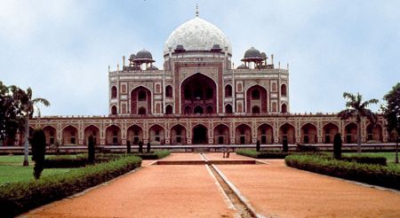
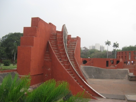
Foto's van New Delhi
Afstanden van New Delhi, Indië
Informatieve materialen - Indië
Valuta Indië, Indiase Rupee
Valuta calculator Indiase Rupee
Ambassades Indië
Kaart van India
Lijst van vliegvelden Indië
Fotogalerij
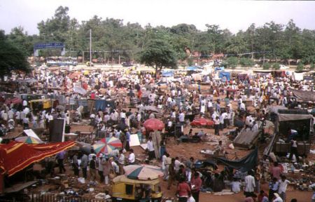
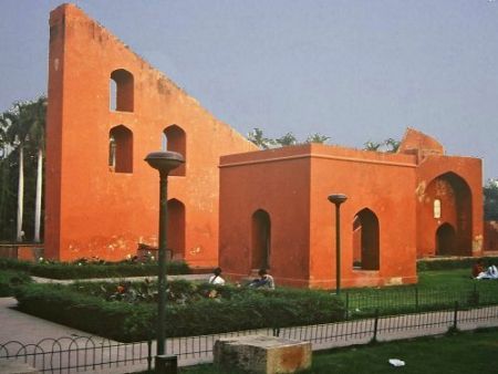
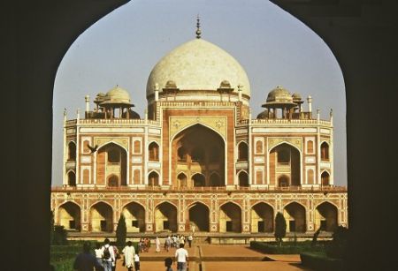
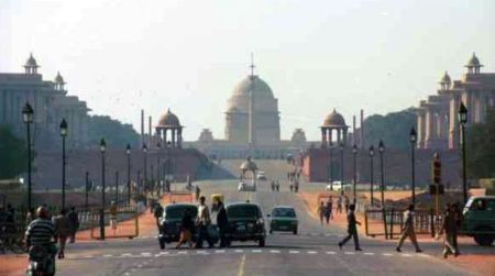
Indië, New Delhi
Voeg uw foto
Foto's van New Delhi »